 HOME
HOME
Evolving drone technology and its associated rules and regulations cut both ways in today’s aviation environment. On the positive side, drones are employed in various reconnaissance roles, from forestry management to law enforcement, and serve as a fast, low-risk platform for prototyping new technologies. Where drones get dicey is when the tech-savvy become curious and want to observe incidents for themselves. Take, for instance, the rash of wildfires in California and across the United States in January 2025; in theory, winter in the United States and outside of what is considered the “normal” fire season.
During the first seven days of the battle to control the Palisades Fire, a suburb of Los Angeles, California, more than 48 privately owned drone incursions were recorded. Three operators of those drones were reportedly arrested. According to the Los Angeles County Fire Department, there were more than 500 drone incursions during the 24 days first responders fought the fire (Jan. 7 to 31, 2025).
“The potential for something bad to happen increased exponentially every time we had to divert [air attack] aircraft. The aircraft are
supposed to be in that area to make sure that people's homes and the crews of firefighters in the area calling in drops are safe,” said LA
County Fire Captain Hans Christen, the department’s UAS manager. “Because of the drone incursions, there were several hours of time where we
had to pull our crewed aircraft out of the area as it was unsafe for them to be there.”
 The
most dangerous incident occurred on January 9, 2025, at approximately 10 a.m., local time, over the Pacific Ocean while a contracted
Canadair CL-415 Super Scooper, capable of dropping 1,600 gallons of water per pass, was fighting the Palisades Fire. The Super Scooper
flying at close to 200 mph under visual flight rules struck a small commercial drone.
The
most dangerous incident occurred on January 9, 2025, at approximately 10 a.m., local time, over the Pacific Ocean while a contracted
Canadair CL-415 Super Scooper, capable of dropping 1,600 gallons of water per pass, was fighting the Palisades Fire. The Super Scooper
flying at close to 200 mph under visual flight rules struck a small commercial drone.
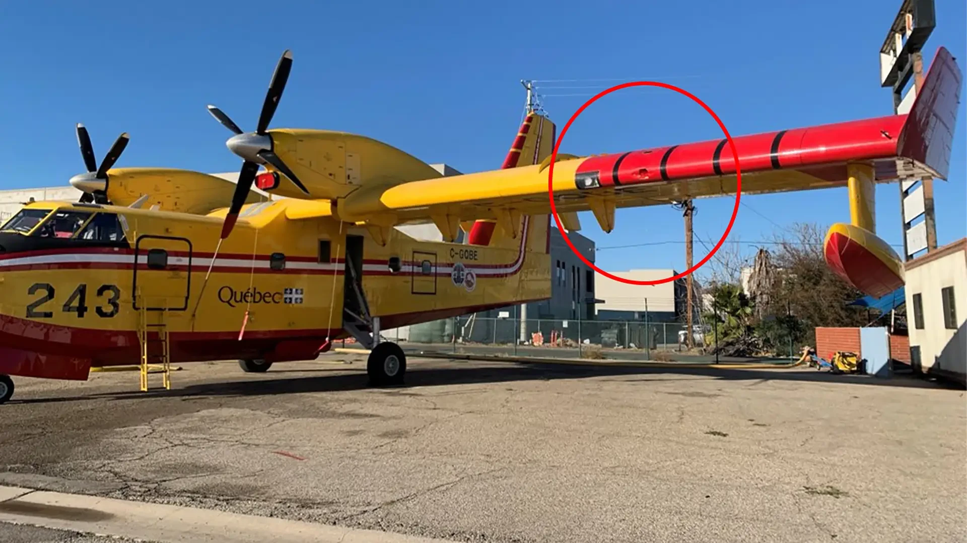
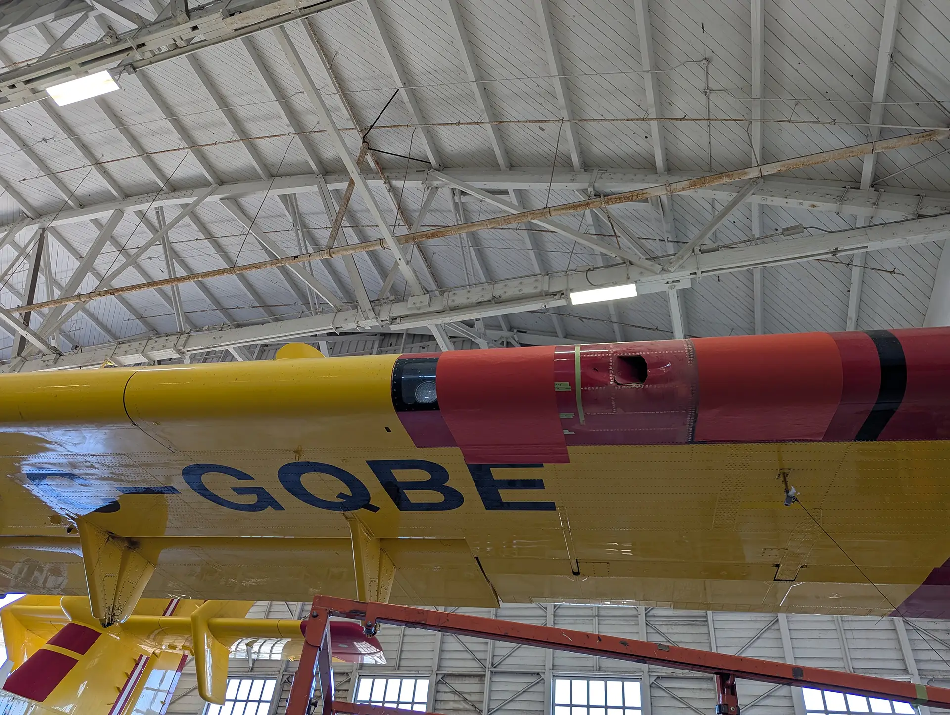
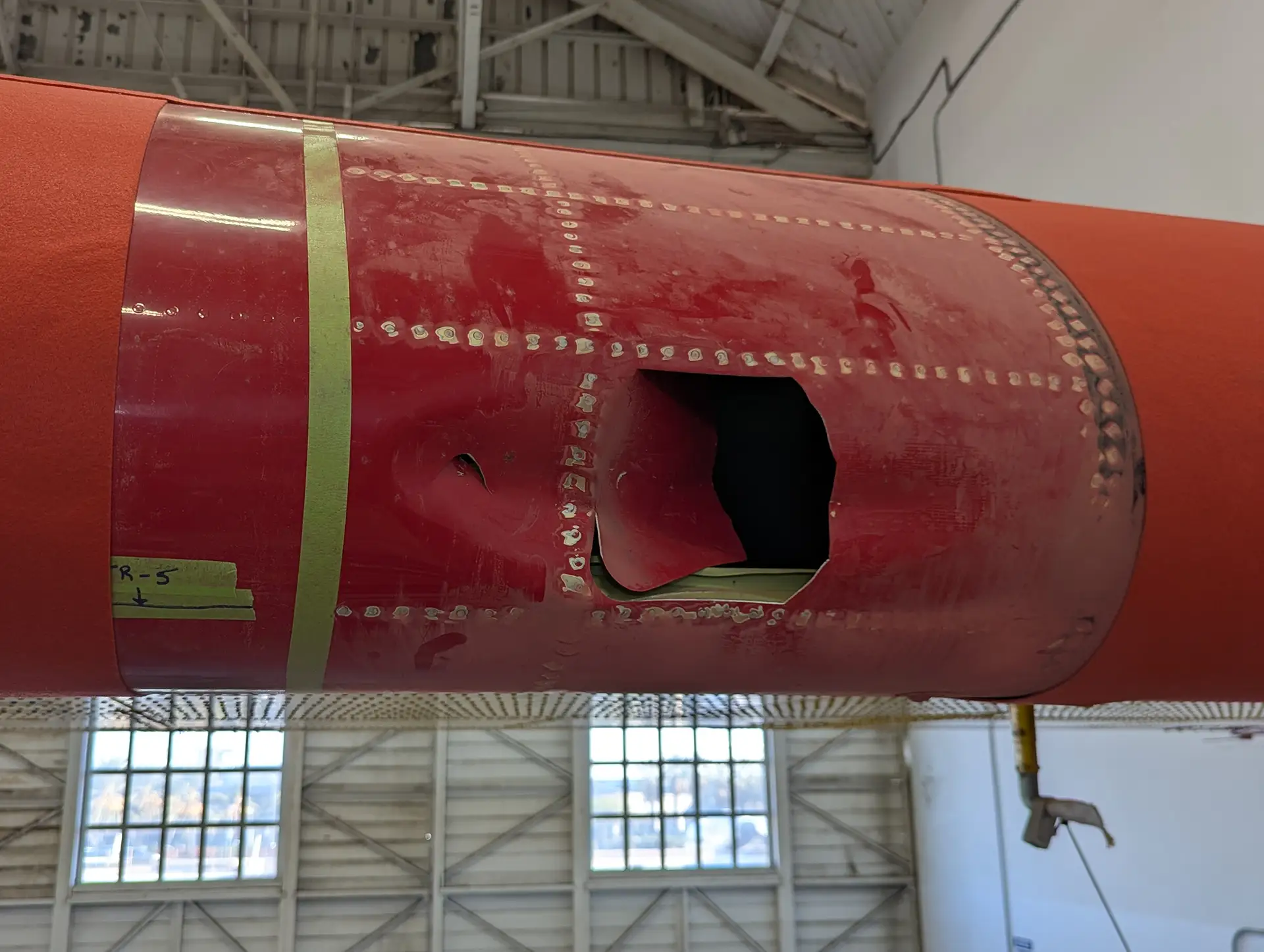
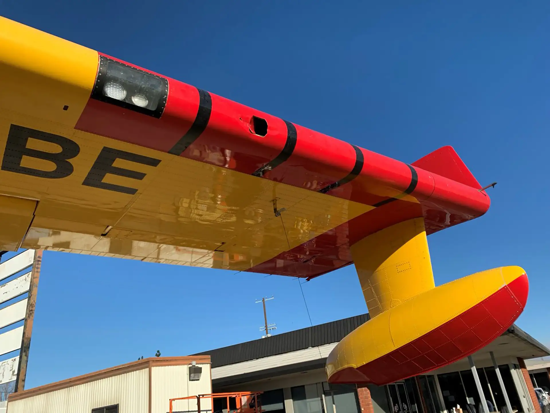
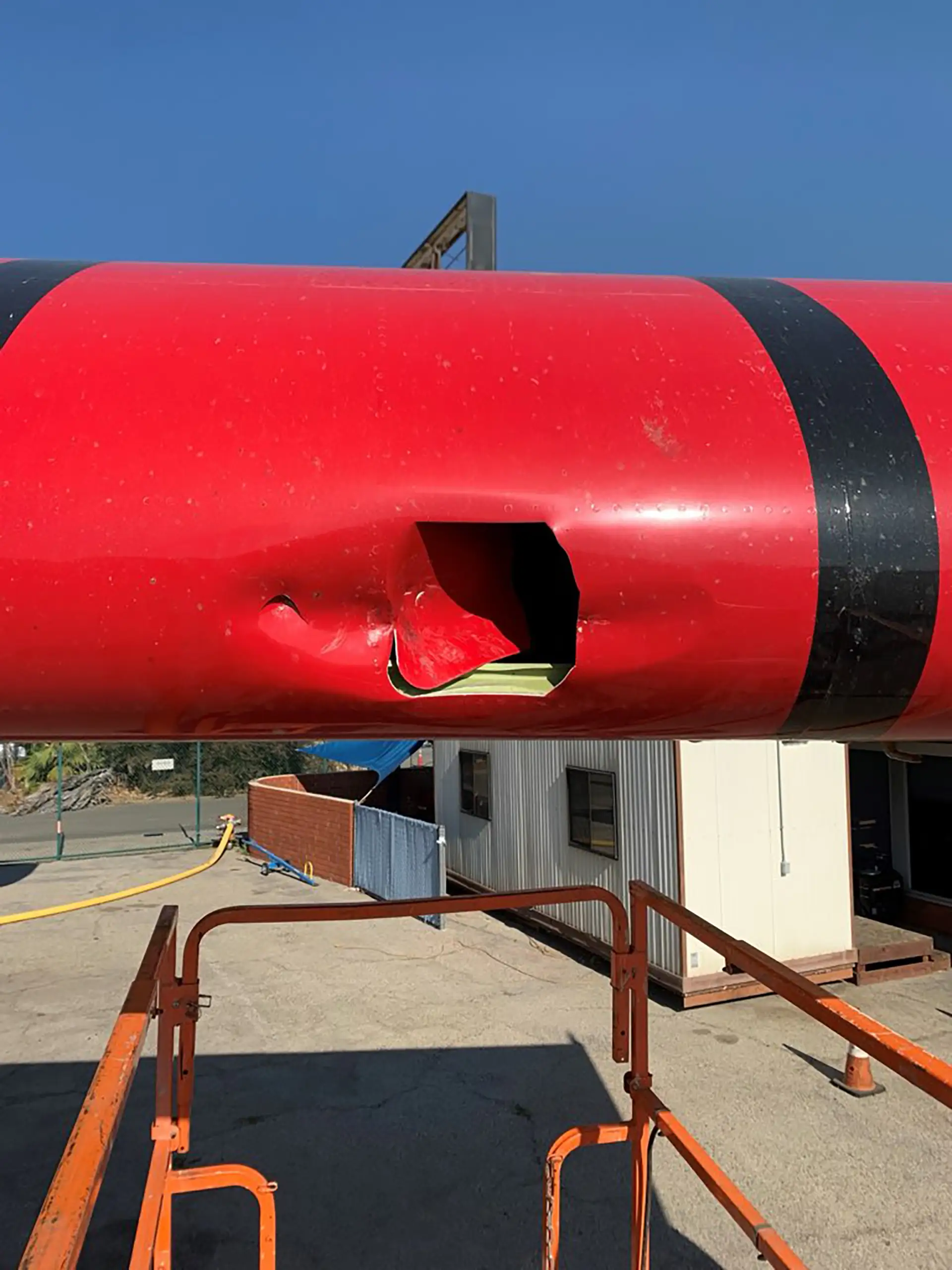
Fortunately, the Super Scooper (fuselage number 243, registered C-GQBE) was able to climb above the Santa Monica Mountains and return to its base at Van Nuys Airport in the San Fernando Valley. The crew was not injured; however, the mid-air collision forced firefighters to suspend all aerial operations for 30 minutes while they ensured the air crew was safe and the sky was clear of privately operated drones.
Upon landing, it was found that the drone had pierced the left wing’s leading edge and was embedded inside the structure. The results could
have been extremely tragic had the drone impacted the cockpit windshield or a propeller. The CL-415, known as “Quebec 1,” was grounded
until parts could be shipped from Canada and the wing repaired. Thus, one less aircraft was able to drop water on the fire, an estimated
loss of more than 96,000 gallons during the five days the Super Scooper sat on the tarmac.
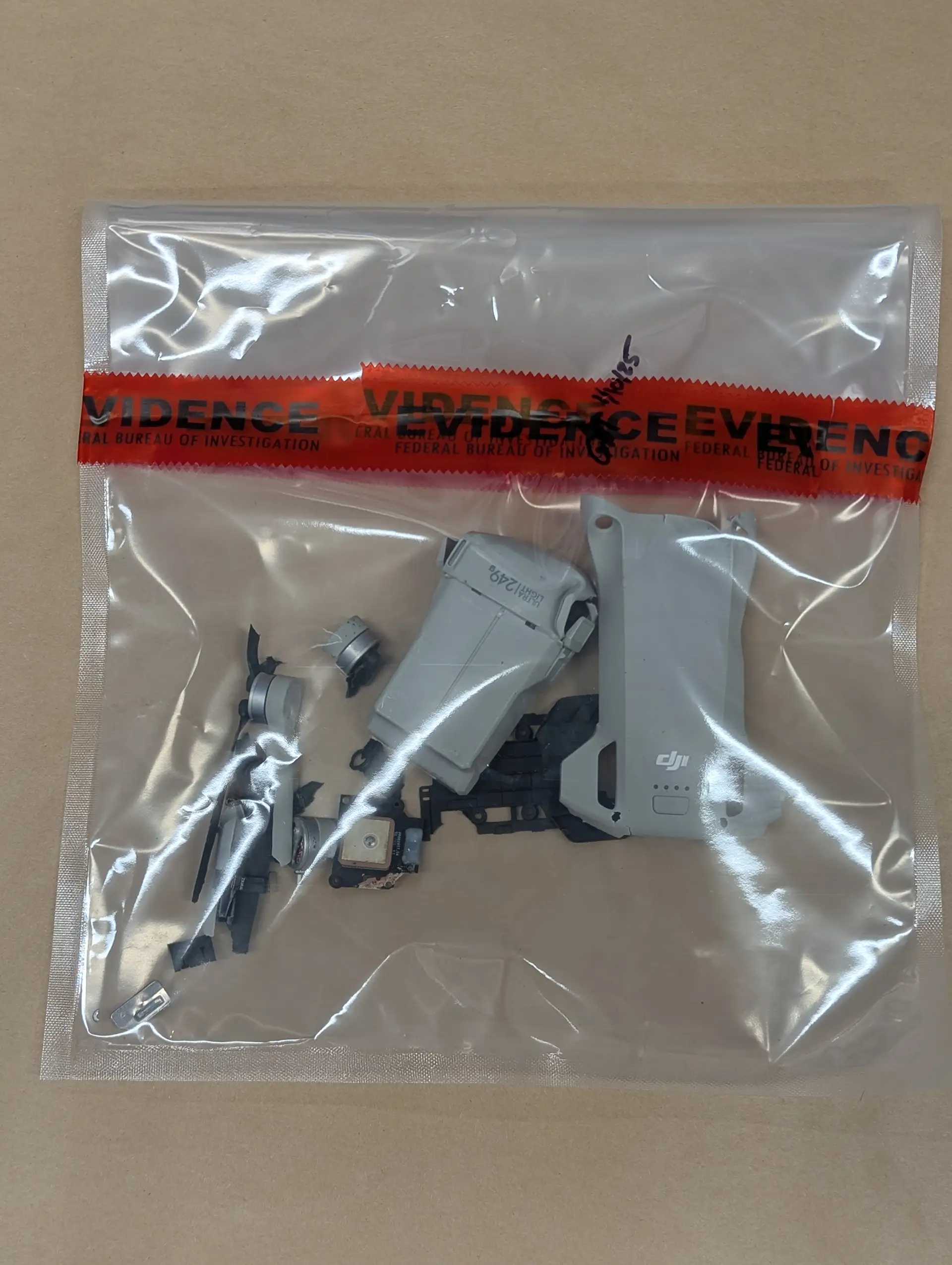
After an extensive investigation by the Los Angeles County Sheriff, Fire Department, and FBI agents, the drone’s owner, Peter T. Akemann, of
Culver City, was arrested. Akemann had launched his drone from a location in nearby Santa Monica and flew approximately 1.5 miles toward the
Palisades Fire before losing visual contact with the drone. Unable to see and avoid air traffic, Akemann’s drone impacted the left wing of
“Quebec 1” as it was returning to drop more water on the fire. After being tracked down by the FBI, Akemann was brought before a judge,
where he pleaded guilty to recklessly operating a drone. He agreed to pay full restitution to the aircraft’s owners, the government of
Quebec, as well as the company that performed the wing repairs. He was also sentenced to 150 hours of community service.
GeoFencing: Pluses and Minuses
One of the largest makers of commercial or consumer drones, as opposed to larger Uninhabited Aerial Systems (UAS) as used by first responders, is Da-Jiang Innovations, or DJI, of Shenzhen, Guangdong, China. In addition to manufacturing commercial drones and UAS systems, the company is an innovator in camera systems and the infrastructure to support them, such as gimbal stabilizers and the associated software to operate the products. According to the MIT Technology Review, in June 2024, DJI controlled 90 percent of the worldwide drone market.
The company had been using TFR, or Temporary Flight Restriction data from the European Aviation Safety Authority (EASA), the UK Civil
Aviation Authority (CAA), and the FAA to create geofences; invisible, electronic boundaries around restricted areas that prevent a drone
from violating the airspace boundary. Typically, geofences were preprogramed and updated in the drone’s operating software and the
electronic boundaries were found bordering airports and sensitive military or government locations. DJI introduced the first geofencing
system in 2013.
Should a fire break out in an area, under the geofence system, the FAA would have to declare a TFR. Then the drone manufacturer would have
to be informed and enter that information into their system. The updated data then needed to be pushed out to operators. The drone operator
would then need to update the drone’s operating application to display the newly announced restricted area and its associated geofence. The
system was certainly cumbersome, which is why regulators moved away from it. In addition, eliminating the geofence system transitions
responsibility for safe operation of the drone from the manufacturer or software vendor to the craft’s operator.
In the ensuing decade since geofences were enacted, commercial drones became smaller, and the declining retail price put acquisition within the financial reach of millions of consumers. Simultaneously, drone regulations have grown in an effort to corral the proliferation of the small flying camera systems as well as to address privacy concerns.
In the United States, all drones must be registered with the FAA, and if they are under 55 pounds in weight, operations are governed by 14
CFR Part 107
known as the “Small UAS Rule.” Within these rules is an “Exception for Limited Recreational Operations of Unmanned Aircraft” (USC
44809),
which enables a person to “operate a small unmanned aircraft without specific certification or operating authority from the Federal Aviation
Administration” if, essentially, the drone is flown for recreational purposes, flown safely within visual line of sight of the operator or
an observer co-located and in direct communication with the operator, does not interfere with and gives way to any manned aircraft, and the
drone does not exceed 400 feet in altitude when flying in uncontrolled airspace.
In the European Union, regulations required that by January 2024, drone manufacturers were to eliminate geofences and replace them with
access to geographical zone data provided by aviation authorities in European Union Aviation Safety Agency (EASA)
member states.
One year later, at the time of the Palisades Fire, there was a TFR, or Temporary Flight Restriction in place surrounding the fire zone. For operators, boundaries of the TFR were fed into the operating software, creating a geofence that prevented flight operations in the TFR zone.
Five days into the fire, drone maker DJI rolled out its planned transition away from its geofencing system, which relied on International Civil Aviation Organization (ICAO) (Annex 14, Aerodromes) airport and airspace configuration data in the United States to better align with up-to-date FAA datasets. Up to Jan. 13, 2025, the company’s geofencing system displayed datasets based on FAA data, which was a good thing and a bad thing. As the FAA's temporary flight restricted areas changed, geofencing software was hours behind the changing TFR situation, and it required a drone operator to restart the system to acquire new information. In addition, the geofence would often keep first responders’ UAS craft on the ground, preventing them from flying from within the pre-set, no-fly zone’s boundaries. DJI’s new system imports FAA data and provides alerts in the drone flight software informing operators when they are approaching restricted flight zones. This change provides greater, up-to-the-minute restriction warnings, yet puts the onus on drone operators to be educated in how to safely operate their craft and respect restricted airspace.
In addition, the FAA has approved five companies to provide information to drone controllers about airport vicinity airspace, controlled airspace, special use airspace, TFRs, national park flight restrictions, and military training areas. Software from these companies provides interactive maps with airspace restrictions, and on-screen safety of flight information. Those companies are Airspace Link, Aloft, AutoPylot, Avision, and UASidekick. All five provide software for use on Android, Apple OS, and desktop platforms.
Drone Incursions During Aerial Firefighting
Operating under both geofences and the subsequent change to FAA TFR data during the Palisades Fire, there were still the aforementioned 500 drone incursions. Each drone is registered with the FAA and broadcasts its ownership information through a transponder-type system known as “Remote ID.” The system broadcasts the drone’s (owner and type information), its location and altitude, and the location of the control station or where the drone took off from. If a drone flies into restricted airspace, which is set forth by the FAA, an incursion of this type falls under the jurisdiction of federal law enforcement.
Interacting with the Remote ID system, the number of incursions during the Palisades Fire was tracked electronically, monitored, and
recorded by the LA County Fire Department’s Homeland Security Section. “We have five captains and all of us are on a counter UAS team, which
is also comprised of the members of the FBI and the Los Angeles County Sheriffs’ Office,” said Captain Christen. “We also do drone detection
with them, and that's how we're able to enforce rules, regulations, and laws that people are breaking. As firefighters, if someone is flying
a drone in a restricted area, we don't have authority to do anything as far as ticket or arrest, whereas the FBI, since they're a federal
agency and the laws regarding airspace are federal, they have the authority to issue citations or build a case against that person if they
are going to go that route.”
In the case of the midair collision between the drone and the Super Scooper, the exact impact point could not be determined, whether it was inside or out of the TFR; however, the operator had lost sight of the drone, and he failed to avoid the path of the waterbomber. Both are violations of the drone operator regulations. An incident of this type falls under federal law enforcement jurisdiction, and the incident was handled by the FBI in coordination with the Los Angeles County Sheriff’s Department.
Moving Forward
The unknown moving forward is whether the drone/Super Scooper mid-air will require drone operators to step up and educate themselves on their responsibility for safely flying their drones in light of the elimination of geofences. And will the massive numbers of drone incursions into fire operation areas be reduced or eliminated?